1873 Geneva Bird’s-Eye View
By Anne Dealy, Director of Education and Public Information
This spring, I developed a program for third graders in which we compared historic views of Geneva to learn how people had changed the environment over time. We examined an 1873 bird’s-eye view of the village and a map from a 1904 atlas of Ontario County. We will follow up our explorations this June with a bus tour of the lakefront to compare what students can see today to the historic documents.
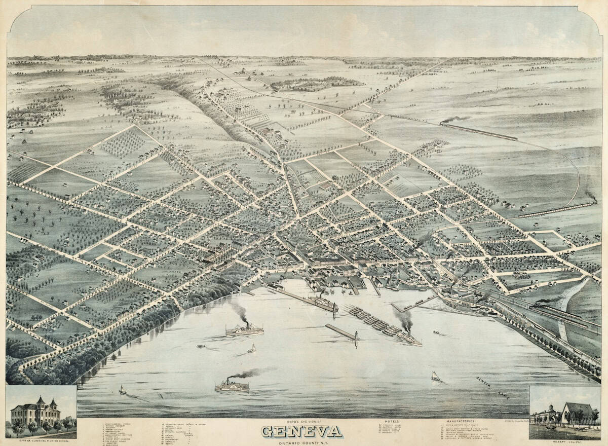
The 1873 Geneva Bird’s Eye View by Augustus Koch.
Working with these documents reminded me how much we can learn about Geneva’s past from maps and similar documents. Many of us are fascinated with how the built environment around us has changed over time. At Historic Geneva we are fortunate to have a large photo collection that helps us to show this change, as we did in the Geneva Then and Now exhibition a few years ago. Besides photographs, we have maps, paintings, and prints of the city that show how it has developed.
The 1873 document I used with the students is a lithograph based on a drawing by Augustus Koch. It shows the village of Geneva from a panoramic or bird’s-eye view from a point over Seneca Lake. This was usually done by the artist’s use of perspective, rather than from a perch in the air. Streets are laid out and labeled. Individual buildings are drawn accurately, and important civic and commercial buildings are labeled.
Views like this were common in the 19th-century U.S. By one count, artists created bird’s-eye views of over 2,500 American places in the 1800s. They were part map, part directory, and part advertisement. They displayed Americans’ civic pride in their communities, institutions, and growing businesses. They decorated American parlors along with prints of the Founding Fathers, military leaders, scenic vistas, Biblical and historical stories, and wonders of American ingenuity like the Erie Canal and Transcontinental Railroad.
Augustus Koch 1 was a German immigrant who served as a draftsman during the Civil War. He was a prolific itinerant artist after the war, creating at least 110 views of communities across the young nation. He was one of a group of men who traveled the United States and its territories during the century, creating lithographed views. Most of his work illustrated communities in the West and Midwest, but he created a handful of maps in western New York in 1873.
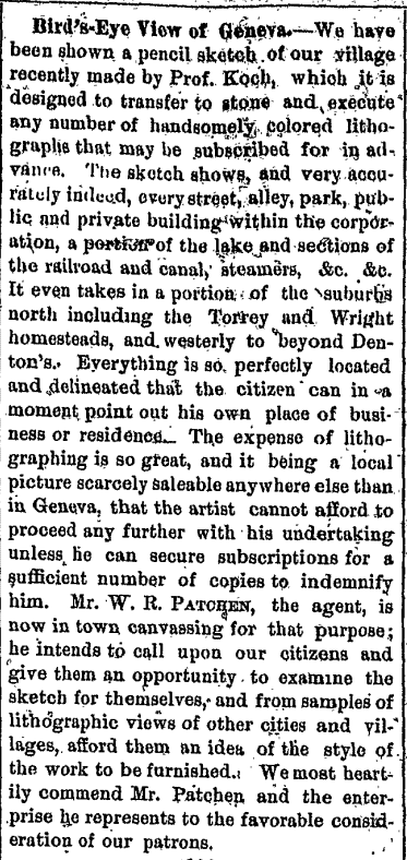
Notice promoting Augustus Koch’s 1873 Geneva Bird’s-Eye View in the Geneva Gazette, August 29, 1873.
Artists like Koch or their agents traveled to communities, sketched the city or village, then advertised in the newspaper, requesting subscriptions (presales) to cover the expense of lithography. They approached civic officials, churches, and businesses with large and distinctive buildings. These buildings and the homes of the wealthy were shown in detail to encourage sales. For an extra charge, a business or organization could have their building labeled on the map. Most agents marketed their product with boilerplate descriptions of the process and the artwork. They published these notices in local newspapers during the sketching process, encouraging residents to show their civic pride by purchasing a print for themselves, their business office, or their family members.
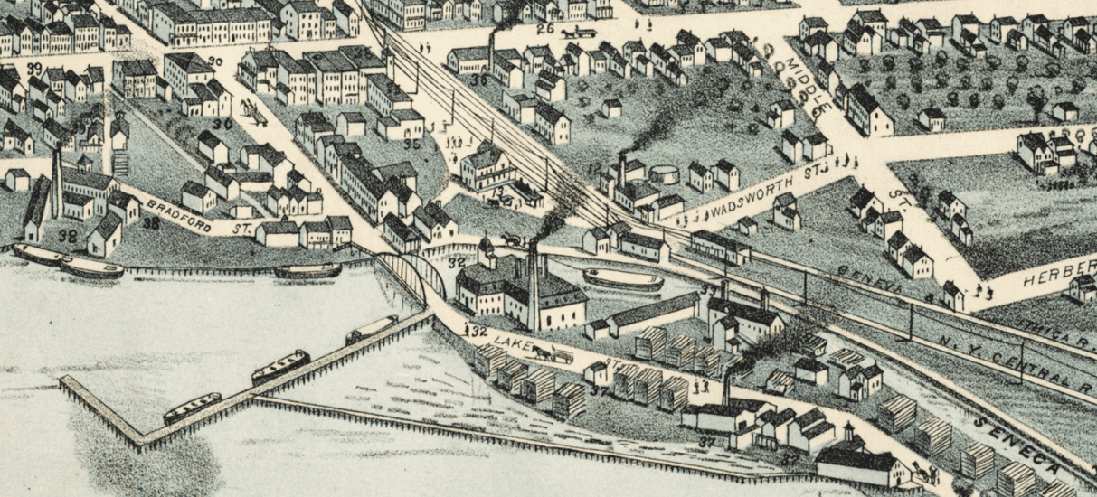
Harbor and Seneca-Cayuga Canal outlet at Lake Street.
The images were promotional and detailed. Smokestacks prominently puffed smoke into the sky from factories, steamboats, and trains. Rather than being a symbol of pollution, they represented progress and prosperity. Harbors were full of boats, and there was no sign of poverty, dumping grounds, or slums in the images. These views sometimes drew immigrants from other communities, since the depictions indicated there were jobs in the community.
Koch’s view of Geneva gives us a clear sense of the changes made to the waterfront in the last 150 years. Although the picture shouldn’t be taken completely at face value, it corresponds accurately to other maps of Geneva at this time. The Seneca-Cayuga Canal enters the harbor at Lake Street, about where today’s New York State Visitor Center is located. The New York Central and Geneva and Ithaca train lines run close to the harbor, but the Lehigh and Fallbrook lines to the west and south had not been built yet. The Geneva and Southwestern line to Naples was in development and imaginatively runs in the distance. However, the financial panic of 1873 led to abandonment of the project, and it was never constructed.

Greenhouses of the nurseries along Castle Street in the 1873 Bird’s-Eye View.
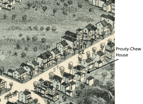
Trinity Church and houses on South Main Street.
The nurseries along Castle Street and their greenhouses are shown. Someone saw fit to pay for insets of the Classical and Union School and Hobart College in the corners of the map. Ten churches are numbered, along with five hotels. Seven factories are listed. The Prouty-Chew House is visible on South Main Street, as is today’s President’s House at Hobart and William Smith Colleges.
Lucien Burleigh made another bird’s eye view of Geneva in 1893 at the end of the art form’s popularity. The financial depression that year probably affected sales. Young artists no longer wanted to wander U.S. communities creating promotional drawings, and tastes were changing. People were leaving small towns for opportunities in the growing cities. American cities were now too large for an artist to capture in one drawing, which became outdated as soon as it was printed. By the early 20th century, aerial photography made the bird’s-eye view obsolete, and no further views were made of Geneva.
Footnotes
[1] Koch’s birth and death dates vary in online sources. There was a German man of the same name who lived around the same time and was an artist and cartographer in New Zealand. The latter seems to have been born in 1834. Augustus Koch may have been born in 1840 and seems to have died around 1900 in California, but I have not found reliable sources to verify this.
Sources
Reps, John William. Views and Viewmakers of Urban America: lithographs of towns and cities in the United States and Canada, notes on the artists and publishers, and a union catalog of their work, 1825-1925. Columbia, MO: University of Missouri Press, 1984.
https://clements.umich.edu/exhibit/birdseye-views/
https://www.geographicus.com/P/ctgy&Category_Code=kochaugustus
https://blogs.loc.gov/maps/2022/12/new-interactive-map-showcases-the-panoramic-maps-collection/
https://www.raremaps.com/mapmaker/2129/Augustus_Koch
https://www.vintagecitymaps.com/history/
Great! Send some more images next month.
Interesting piece. And it seems like a great way to engage young students in examining history. Nice work.