Every Building Tells a Story: Retail Architecture, Part II
By John Marks, Curator of Collections and Exhibits
The geography of business is constantly changing. A William Smith student once asked me, “Why does Geneva have two downtowns?” She was referring to Hamilton Street as a retail corridor, which began in the late 1950s. While downtown was a focal point in the 19th and 20th centuries it wasn’t the only location of businesses.
Older readers (yes, I’m afraid I mean you, you, and you over there) remember neighborhood stores throughout the city. While there were a few liquor stores and dry cleaning shops the bulk of the businesses were grocery stores and restaurants. In the 1948 city directory there were 45 grocery stores. Many were independent stores; there were eight Market Basket locations (a Geneva-based corporation) but most of them were away from downtown.
Architecturally what stands out for me was the number of residential-business combinations. The houses were built first, followed by a commercial addition decades later where lot size allowed. Sanborn fire insurance maps offer a rough idea of when additions were built; the maps were done in 1925 and 1947.
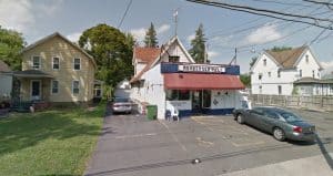
East North Street has several surviving examples. In 1948, Best Market (now Momberger’s Deli) at 297 East North Street was owned by Joseph Azzarello who lived behind the store.
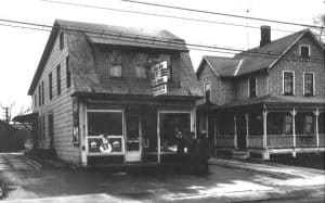
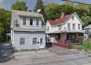
Going west on the same street there was Irnea Mulvey’s store, not to be confused with Mulvey’s Market on North Genesee Street. Mr. Mulvey didn’t live at that address but rented the house portion. No longer a business, one can still see that the front has been altered and had a different use in the past.
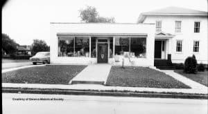
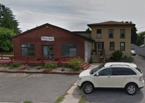
Joseph DeMeo owned a grocery on the corner of East North and Munson Streets. Blown Away hair salon has changed the exterior and roof line but the house remains the same.
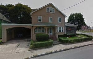
Finally, the Saglimbeni family has lived and operated a store at 30 East North Street for decades. A grocery during Prohibition, it became a liquor store upon repeal and is still active.
This is a shadow of neighborhood businesses of 70 years ago. Competition from large supermarkets played a part in their demise. Their replacement was slowed, if not forbidden, by city zoning ordinances that were implemented in 1968. Opening a restaurant, grocery, or liquor store on a residential street became more difficult.
Rather than detailing every local business in blog form, the Historical Society will be introducing GIS maps on our website. The most common geographic information system (GIS) is a Google map on a cellphone. Gas stations, ATMS, hotels, etc. pop up as points on a map relative to wherever you are. You can click on a point that may have photographs, link to a website, or allow you to make reservations.
GIS maps work well for history because they offer choices of information. Rather than reading pages of text you can look at a Geneva map and click on points of interest for more information. A point may have text, photos, or links to blogs, podcasts, or videos. This concept can be applied to industry, restaurants, schools, churches, or just about any topic.
This is new technology for the Historical Society and may take a while to master but stay tuned to our website and Facebook for announcements!
