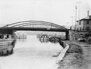
Seneca-Cayuga Canal and the Seneca Lock Navigation Company
(From the October 2003 Historical Society Newsletter.
2025 marks the bicentennial of the Erie Canal. The Seneca-Cayuga Canal connected Geneva to the Erie Canal.)
There was interest in improving the outlet of Seneca Lake for navigation as early as 1792 when the state chartered the Western Inland Navigation Company to improve the channel of the Mohawk River and build canals and lock to both Seneca Lake and Lake Ontario. The impulse to build a water transportation network between New York City and the rest of the state arose from the need to compete with Philadelphia, which at the time received and shipped more goods than New York. Interest in a water route was furthered by the need to divert trade from the St. Lawrence and the foreign ports of Canada to Albany and New York. According to the January 17, 1816 issue of the Geneva Gazette the Wester Inland Navigation Company had made little progress toward these objectives.
As early as 1812, Geneva businessmen had been petitioning the state to develop a canal system which would provide an efficient, cheap system to ship the agricultural products and raw materials produced in this area of the country to Albany. Only a about one hundred miles of canal had been constructed in the United States by 1816, just one year before the authorization of the Erie Canal. In Geneva, the Seneca Lock Navigation Company had been to existence for three years and the Cayuga and Seneca Canal Company had been chartered the year before to connect the lake with Montezuma, the swamp at the foot of Cayuga Lake through which the Erie Canal would later run. Moreover, the directors of the Seneca Lock Navigation Company had organized the Seneca and Susquehanna Lock Navigation Company that same year with the aim of building locks and canals from the headwaters of Seneca Lake to the Chemung and Susquehanna Ribers to create a navigation route from Lake Ontario to the Chesapeake Bay. All three companies requested the state’s aid in these improvements, but no interior was shown until the Erie Canal was completed and had begun to show its immense profitability.
In the meantime, the Seneca Lock Navigation Company did not stand idle. In 1815, it changed the course of the meandering lake outlet. The outlet was located at the extreme northeast corner of the lake. From there it flowed south, then curved north toward Waterloo. At the curve, the company cut a channel straight through to the lake. However, the fury of the south winds not only buffeted vessels about, but also created sandbars in the mouth of the outlet. By 1821, the Navigation Company had spent $70,000 to construct a channel that afforded some protection to boats, but the channel was not built through to Geneva.
The canal was evidently not continued to Geneva until after the state assumed control of it in 1825. Genevans again urged the state to be more actively involved in improving the channel. Only after residents of the lake’s north shore offered to give the state right-of-way without compensation did the proposal begin to seem attractive. The Joint Committee on Canals and Canal Improvements recommended that an investment be made based on its conviction that the tolls would pay for the cost of construction. On April 20, 1825 the state officially decided to incorporate the Cayuga and Seneca Canal into its water transportation network and appropriated $150,000 to improve navigation between Seneca Lakes and Erie Canal. This included extending the canal around the north end of the lake, and emptying the channel into the lake just south of Lake Street.
The joint committee was not wrong. In November 1828, water was let from Seneca Lake into every part of the canal, which then took its place as the third canal to be built in New York State. The improvements cost $214,000. In 1827, the Erie Canal collector’s office at Port Byron reported $89,066 in tolls. About $75,000 of which were paid on goods brought down the Seneca and Cayuga Lakes about $40,000 of that appears to have come from Seneca Lake alone. Between 1820 and 1882 more than a million dollars in tolls were collected on this canal.
Even though its path was not again altered until the twentieth century, the canal into Geneva changed in other ways. In 1834, the original outlet of Seneca Lake was closed. In 1840, high water damage to Geneva wharves, mills, and store houses compelled the construction of a weir (a type of dam) at the northeast corner of the lake to regulate the water level in the canal. The canal was enlarged in 1862, deepened in 1897 and was made part of the Barge Canal system in 1912. By early 1911, it was clear that the section of the canal that reached downtown Geneva would be abandoned in preference for the original lake outlet, which was widened and deepened in 1914 to provide an adequate terminal for the Barge Canal. This improvement extended 1000 feet into Seneca Lake and made the outlet 100 feet wide at its bottom, 150 feet at the surface and seventeen feet deep. This is the outlet as we know it today. All that remains of the channel that led to Geneva’s is the area of the state park where the boat launch is located.
This article was brought to you in part by our supporters. Be our partner in telling Geneva’s stories by becoming a Historic Geneva supporter.


Great article about the Seneca-Cayuga & Erie Canal.