The Pre-Emption Line, Part 4
By John Marks, Curator of Collections
When we left off in July, Hugh Maxwell had finished the official (and inaccurate) survey of the Pre-Emption Line for the Phelps and Gorham Purchase. He went on to survey the townships so land sales could begin. In his field notes in the Historic Geneva archives, he specifically mentioned allowing for magnetic variance each time he surveyed a northern line.
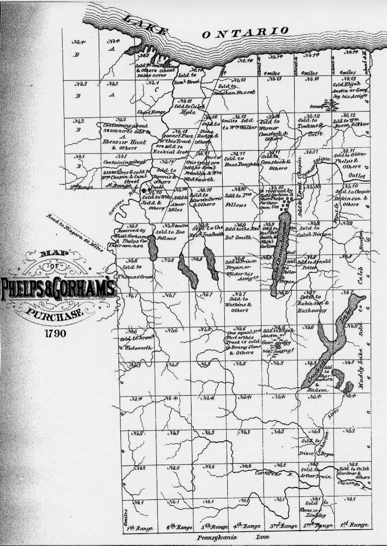
1790 map of the Phelps and Gorham Purchase.
In 1790, the Phelps and Gorham investors were unable to meet their payments to Massachusetts. Land sales didn’t meet their expectations, and the rising value of Massachusetts currency increased the size of the mortgage. According to their agreement with the state, the right to buy the land west of the Genesee River returned to Massachusetts. Robert Morris purchased Phelps’ and Gorham’s unsold lands, as shown on the map to the left
As a Founding Father, Morris was a signer of the Declaration of Independence, the Articles of Confederation, and the Constitution. Later in life he began buying and selling large tracts of land. After purchasing the remainder of Phelps’ and Gorham’s land, he sold it the Pulteney Association in England. With the profits, he purchased most of the land west of the Genesee River from the Haudenosaunee. It was then sold to the Holland Land Company. Morris kept 500,000 acres for himself, a narrow tract called the Morris Reserve.
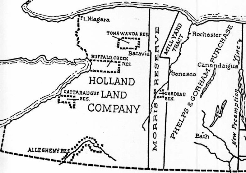
Map of the Holland Land Company, Morris Reserve, and Phelps and Gorham Purchase, ca 1800
In 1792, the Pulteney Associates (Sir William Pulteney, William Hornby, and Patrick Colquhoun) took over the Phelps and Gorham Purchase. (In spite of the Pulteney group owning and developing the land far longer than Phelps and Gorham, their name never historically stuck.)
The first order of business was determining a correct Pre-Emption Line. In November and December 1792, Benjamin Ellicott, assisted by James Armstrong, Frederick Saxton and Augustus Porter, resurveyed Maxwell’s original line and plotted what is known as the “new” Pre-emption Line. Mr. Ellicott attached an oath to the map, certifying that it was an “accurate representation of the eastern boundary of Massachusetts as run by himself and others.” Finally, in April 1796, the New York State Legislature adopted the Ellicott survey as the final word on the location of the Pre-emption Line.
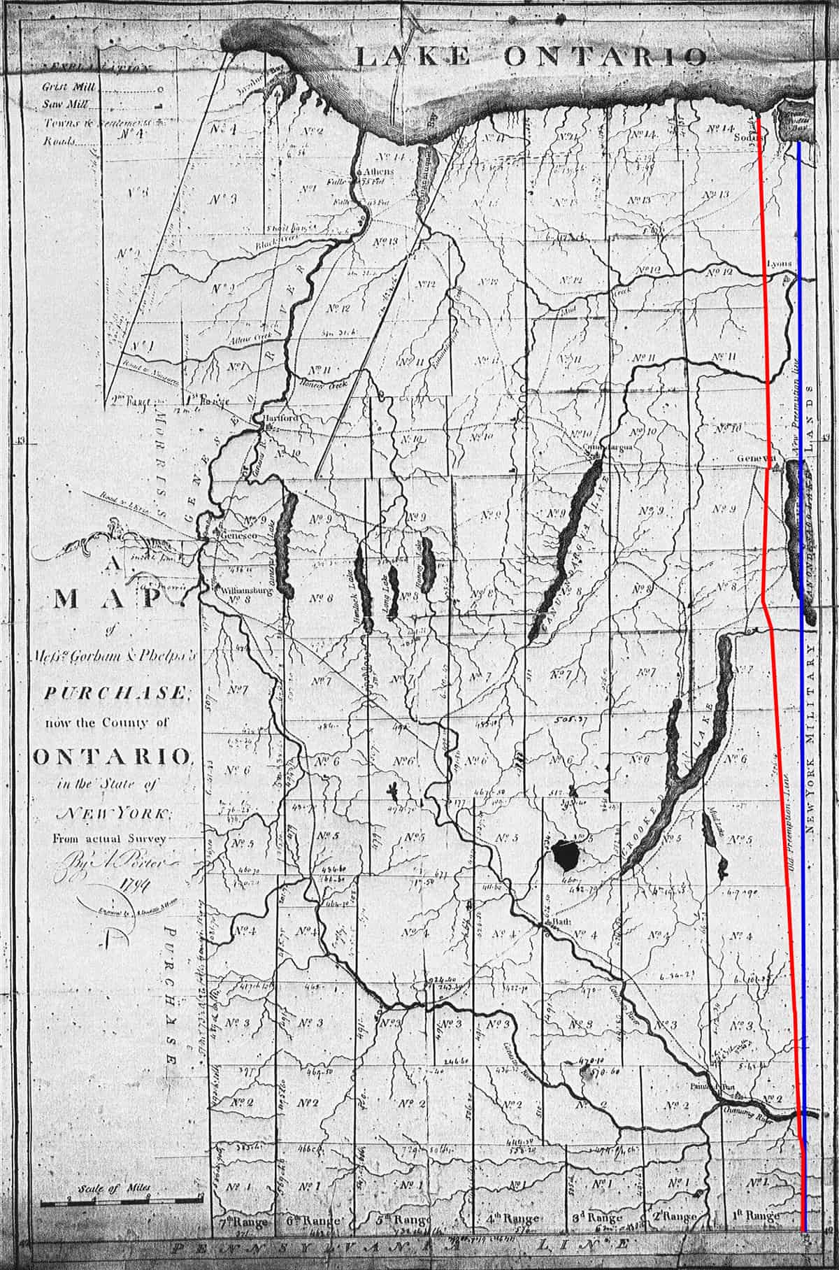
1794 map showing the “old” and “new Pre-emption Lines.
The roughly 86,000 acres between the “old” and “new” lines were known as “the Gore.” New York State had already sold the land, thinking they owned it. As compensation, the state gave the Pulteney Associates three or more acres of land east of the Pre-Emption Line for each acre they had sold in the Gore.
Locally, the two surveys live on in road names. Pre-Emption Road follows Maxwell’s line from Penn Yan to west of Lyons. Other roads, north and south of Geneva, follow the original line. Pre-Emption Street, the border between Seneca and Ontario Counties, follows the correct line. That road is further confused by signs calling it both Pre-Emption Street and Townline Road.
What became of Phelps and Gorham? They live on through the towns named after them, famous for sauerkraut and marching bands, respectively. Nathaniel Gorham never recovered financially or socially from his failed investment. In 1796, he died in Charlestown, Massachusetts. Oliver Phelps invested heavily in land in New York, Georgia, West Virginia, and Maine. Around 1800, changing money values and a depressed land market hurt him financially. He moved to Canandaigua, was appointed the first judge of Ontario County, and served one term in Congress. In 1809 Phelps died in debtor’s prison.
Additional Pre-Emption Line Blog Articles
John, Do you know how the size of townships within the early Phelps Gorham tract were determined? Townships varied in acreage size.
Whatever happened to the blue & yellow sign that used to identify this topic at the corner of 5&20 and county Rd 6?
As with several local historic markers, this one disappeared without a trace.